Alberta -Edmonton
Alberta is a Canadian province. With a population of 3,645,257 in 2011 and an estimated population of 4,145,992 as of October 1, 2014, it is Canada's fourth-most populous province. Alberta and its neighbor, Saskatchewan, were established as provinces on September 1, 1905.
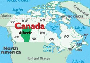
It is bounded by the provinces of British Columbia to the west and Saskatchewan to the east, the Northwest Territories to the north, and the U.S. state of Montana to the south. Alberta is one of three Canadian provinces and territories to border only a single U.S. state and is also one of only two provinces that are landlocked.
Alberta is named after Princess Louise Caroline Alberta, the fourth daughter of Victoria, the Queen of Canada and Albert, Prince Consort.
Edmonton is the capital city of Alberta and is the primary supply and service hub for Canada's crude oil, oil sands (Athabasca oil sands) and other northern resource industries. Calgary is Alberta's largest city. The city is a staging point for large-scale oil sands projects occurring in northern Alberta and large-scale diamond mining operations in the Northwest Territories.
The city had a population of 812,201 in the 2011, making Alberta second-largest city and Canada's fifth-largest municipality.
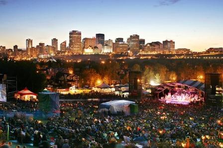
Edmonton is a cultural, governmental and educational center. It hosts a year-round slate of festivals, reflected in the nickname "The Festival City". It is home to North America's largest mall, West Edmonton Mall (the world's largest mall from 1981 until 2004), and Fort Edmonton Park, Canada's largest living history museum.
Geography of Alberta
Alberta, with an area of 661,848 km2 is the fourth largest province after Quebec, Ontario, and British Columbia Alberta is bordered by the U.S. state of Montana on the south side, on the north by the Northwest Territories, on the east by the province of Saskatchewan, and on the west by the province of British Columbia.
The province extends 1,223 km north to south and 660 km east to west at its maximum width. Its highest point is 3,747 m at the summit of Mount Columbia in the Rocky Mountains along the southwest border, while its lowest point is 152 m on the Slave River in Wood Buffalo National Park in the northeast.
The province has adequate water resources. There are numerous rivers and lakes used for swimming, fishing and a range of water sports. There are three large lakes, Lake Claire in Wood Buffalo National Park, Lesser Slave Lake and Lake Athabasca which lies in both Alberta and Saskatchewan. The longest river in the province is the Athabasca River which travels 1,538 km from the Columbia Icefield in the Rocky Mountains to Lake Athabasca. The largest river is the Peace River with an average flow of 2161 m3/s. The Peace River originates in the Rocky Mountains of northern British Columbia and flows through northern Alberta and into the Slave River, a tributary of the Mackenzie River.
Edmonton is located approximately in the geographic center of the province. Due to its proximity to Canada's largest oil fields, Edmonton has most of western Canada's oil refinery capacity. Calgary is located approximately 280 km south of Edmonton surrounded by extensive ranching country. Almost 75% of the province's population lives in the Calgary and Edmonton.

Most of the northern half of the province is boreal forest; while the Rocky Mountains along the southwestern boundary are largely forested the southern quarter of the province is prairie, ranging from shortgrass prairie in the southeastern corner to mixed grass prairie in an arc to the west and north of it. The central aspen parkland region extending in a broad arc between the prairies and the forests, from Calgary, north to Edmonton, and then east to Lloydminster, contains the most fertile soil in the province and most of the population. Much of the unforested part of Alberta is given over either to grain or to dairy farming, with mixed farming more common in the north and center, while ranching and irrigated agriculture predominate in the south.
The Alberta badlands are located in southeastern Alberta, where the Red Deer River crosses the flat prairie and farmland, and features deep canyons and striking landforms. Dinosaur Provincial Park, near Brooks, Alberta, showcases the badlands terrain, desert flora, and remnants from Alberta's past when dinosaurs roamed the then lush landscape.
Climate of Alberta
Alberta has a dry continental climate with warm summers and cold winters. The province is open to cold arctic weather systems from the north, which often produces extremely cold conditions in winter. As the fronts between the air masses shift north and south across Alberta, the temperature can change rapidly. Arctic air masses in the winter produce extreme minimum temperatures varying from −54 °C in northern Alberta to −46 °C in southern Alberta. In the summer, continental air masses produce maximum temperatures from 32 °C in the mountains to 40 °C in southern Alberta.
Alberta extends for over 1,200 km from north to south; its climate, therefore, varies considerably. Average high temperatures in January range from 0 °C in the southwest to −24 °C in the far north. The climate is also influenced by the presence of the Rocky Mountains to the southwest, which disrupt the flow of the prevailing westerly winds and causes them to drop most of their moisture on the western slopes of the mountain ranges before reaching the province, casting a rain shadow over much of Alberta. Because of the province location and isolation from the weather systems of the Pacific Ocean, it has a dry climate with little moderation from the ocean. Annual precipitation ranges from 300 mm in the southeast to 450 mm in the north, except in the foothills of the Rocky Mountains where total precipitation including snowfall can reach 600 mm annually.
In the summer, the average daytime temperatures range from around 21 °C in the Rocky Mountain valleys and far north, up to around 28 °C in the dry prairie of the southeast. The northern and western parts of the province experience higher rainfall and lower evaporation rates caused by cooler summer temperatures. Alberta is a sunny province. Annual bright sunshine totals range between 1900 up to just less than 2600 hours per year. Northern Alberta gets about 18 hours of daylight in the summer.
In southwestern Alberta, the cold winters are frequently interrupted by warm, dry chinook (a warm dry wind that blows down the east side of the Rocky Mountains at the end of winter ) winds blowing from the mountains, which can propel temperatures upward from frigid conditions to well above the freezing point in a very short period.
Northern Alberta is mostly covered by boreal forest and has a subarctic climate. The agricultural area of southern Alberta has a semi-arid steppe climate because the annual precipitation is less than the water that evaporates or is used by plants. The southeastern corner of Alberta, part of the Palliser Triangle, experiences greater summer heat and lower rainfall than the rest of the province, and as a result suffers frequent crop yield problems and occasional severe droughts. Western Alberta is protected by the mountains and enjoys the mild temperatures brought by winter chinook winds. Central and parts of northwestern Alberta in the Peace River region are largely aspen parkland, a biome transitional between prairie to the south and boreal forest to the north.
After Saskatchewan, Alberta experiences the most tornadoes in Canada with an average of 15 verified per year. Thunderstorms, some of them severe, are frequent in the summer, especially in central and southern Alberta.
History of Alberta
Indians arrived in Alberta at least 10,000 years ago, toward the end of the last ice age. They migrated from Siberia to Alaska on a land bridge across the Bering Strait, and then may have moved down the east side of the Rocky Mountains through Alberta to settle the Americas. Others may have migrated down the coast of British Columbia and then moved inland.
After the British arrival in Canada, approximately half of the province of Alberta, south of the Athabasca River drainage, became part of Rupert's Land which consisted of all land drained by rivers flowing into Hudson Bay. This area was granted by Charles II of England to the Hudson's Bay Company in 1670. French Canadians Arrived in the west around 1731.
The first explorer of the Athabasca region was Peter Pond. Fur traders formed the North West Company (NWC) of Montreal to compete with the HBC in 1779. The NWC occupied the northern part of Alberta territory.
The extreme southernmost portion of Alberta was part of the French territory of Louisiana, sold to the United States in 1803; in 1818, the portion of Louisiana north of the Forty-Ninth Parallel was ceded to Great Britain.
Fur trade expanded in the north, but bloody battles occurred between the rival HBC and NWC, and in 1821 the British government forced them to merge to stop the hostilities. The amalgamated Hudson's Bay Company dominated trade in Alberta until 1870, when the newly formed Canadian Government purchased Rupert's Land. Northern Alberta was included in the North-Western Territory until 1870, when it and Rupert's land became Canada's Northwest Territories.
The District of Alberta was created as part of the North-West Territories in 1882. As settlement increased, local representatives to the North-West Legislative Assembly were added. After a long campaign for autonomy, in 1905 the District of Alberta was enlarged and given provincial status, with the election of Alexander Cameron Rutherford as the first premier.
Population of Alberta
In the 2011, Alberta had a population of 3,645,257. With a land area of 640,081.87 km2, it had a population density of 5.7/km2 in 2011. In 2013, Statistics Canada estimated the province's population to be 4,025,073.
Alberta has experienced a relatively high rate of growth in recent years, mainly because of its burgeoning economy. Between 2003 and 2004, the province had high birthrates, relatively high immigration, and a high rate of interprovincial migration when compared to other provinces.
Approximately 81% of the population lives in urban areas and only about 19% live in rural areas. The Calgary-Edmonton region is the most urbanized area in the province and is one of the most densely populated areas of Canada. The Calgary-Edmonton region covers a distance of roughly 400 kilometers north to south.
According to 2006 census, it was found that English, with 2,576,670 native speakers, was the most common mother tongue of Albertans, representing 79.99% of the province's population. The next most common mother tongues were various Chinese languages with 97,275 native speakers (3.02%), followed by German with 84,505 native speakers (2.62%) and French with 61,225 (1.90%).
Alberta has considerable ethnic diversity. In line with the rest of Canada, many immigrants originated from England, Scotland, Ireland and Wales, but large numbers also came from other parts of Europe, notably Germany, France, Ukraine and Scandinavia. According to Statistics Canada, Alberta is home to the second highest proportion (two percent) of Francophones in western Canada (after Manitoba). Despite this, relatively few Albertans claim French as their mother tongue. Many of Alberta's French-speaking residents live in the central and northwestern regions of the province.
As reported in the 2001 census, the Chinese represented nearly four percent of Alberta's population, and East Indians represented more than two percent. Both Edmonton and Calgary have historic Chinatowns, and Calgary has Canada's third largest Chinese community. The Chinese presence began with workers employed in the building of the Canadian Pacific Railway in the 1880s. Aboriginal Albertans make up approximately three percent of the population.
Amongst those of British origins, the Scots have had a particularly strong influence on place-names, with the names of many cities and towns including Calgary, Airdrie, Canmore, and Banff having Scottish origins.
Aboriginal Identity Peoples make up 5.8% of the population, about half of whom consist of North American Indians and the other half are Metis. There is also small number of Inuit people in Alberta.
In 2011 the largest religious group was Roman Catholic, representing 24.3% of the population. Alberta had the second highest percentage of non-religious residents among the provinces (after British Columbia) at 31.6% of the population. Muslims, Sikhs, Buddhists, and Hindus live in Alberta. Muslims made up 3.2% of the population, Sikhs 1.5%, Buddhists 1.2%, and Hindus 1.0%.
Economy of Alberta
Alberta's economy is one of the strongest in Canada, supported by the burgeoning petroleum industry and to a lesser extent, agriculture and technology. The per capita GDP in 2007 was by far the highest of any province in Canada at C$74,825. This was 61% higher than the national average of C$46,441.
According to The Fraser Institute statements, Alberta also has very high levels of economic freedom and rates Alberta as the freest economy in Canada, and the second freest economy amongst U.S. states and Canadian provinces.
Alberta’s Petroleum Industry
Alberta is the largest producer of conventional crude oil, synthetic crude, natural gas and gas products in Canada. Alberta is the world’s second largest exporter of natural gas and the fourth largest producer. Two of the largest producers of petrochemicals in North America are located in central and north-central Alberta. In both Red Deer and Edmonton, polyethylene and vinyl manufacturers produce products that are shipped all over the world. Edmonton's oil refineries provide the raw materials for a large petrochemical industry to the east of Edmonton. Edmonton also produces a large amount of recycled petrochemical products as well as renewable plastics made from Maize. Together, the metropolitan areas of both Edmonton and Red Deer produce nearly 17% of the world's plastic and renewable plastic materials.
The Athabasca oil sands surrounding Fort McMurray have estimated unconventional oil reserves approximately equal to the conventional oil reserves of the rest of the world, estimated to be 1.6 trillion barrels (254 km3). Many companies employ both conventional strip mining and non-conventional in situ methods to extract the bitumen from the oil sands.
Edmonton & Calgary are industry hotspots for retail chains and entertainment centers, with both cities having the most successful movie theaters, car dealerships and clothing outlets in all of Canada. The two cities are also home to multiple headquarters and major head offices of large/global corporations, and are home to at least 35 business headquarters of the Fortune 500, according to Forbes, with a planned total of 42 by 2017.
Agriculture in Alberta
Agriculture has a significant position in the province's economy. The province has over three million head of cattle, and Alberta beef has a healthy worldwide market. Nearly one half of all Canadian beef is produced in Alberta. Alberta is one of the top producers of plains buffalo for the consumer market. Sheep for wool and mutton are also raised.
Wheat and canola are primary farm crops, with Alberta leading the provinces in spring wheat production; other grains are also prominent. Much of the farming is dryland farming, often with fallow seasons interspersed with cultivation. Continuous cropping (in which there is no fallow season) is gradually becoming a more common mode of production because of increased profits and a reduction of soil erosion. Across the province, the once common grain elevator is slowly being lost as rail lines are decreasing; farmers typically truck the grain to central points.
Alberta is the leading beekeeping province of Canada, with some beekeepers wintering hives indoors in specially designed barns in southern Alberta, then migrating north during the summer into the Peace River valley where the season is short but the working days are long for honeybees to produce honey from clover and fireweed.
The vast northern forest reserves of softwood allow Alberta to produce large quantities of lumber, oriented strand board (OSB) and plywood, and several plants in northern Alberta supply North America and the Pacific Rim nations with bleached wood pulp and newsprint.
Tourism in Alberta
Alberta has been a tourist destination from the early days of the twentieth century, with attractions including outdoor locales for skiing, hiking and camping, shopping locales such as West Edmonton Mall, Calgary Stampede, outdoor festivals, professional athletic events, international sporting competitions such as the Commonwealth Games and Olympic Games, as well as more eclectic attractions. There are also natural attractions like Elk Island National Park, Wood Buffalo National Park, and the Columbia Icefield.
According to Alberta Economic Development, Calgary and Edmonton both host over four million visitors annually. Banff, Jasper and the Rocky Mountains are visited by about three million people per year. Alberta tourism relies heavily on Southern Ontario tourists, as well as tourists from other parts of Canada, the United States, and many international countries.
Alberta's Rocky Mountains include Banff National Park and Jasper National Park. The two mountain parks are connected by the scenic Icefields Parkway. Banff is located 128 km west of Calgary on Highway 1, and Jasper is located 366 km west of Edmonton on Yellowhead Highway. Five of Canada's fourteen UNESCO World heritage sites are located within the province: Canadian Rocky Mountain Parks, Waterton-Glacier International Peace Park, Wood Buffalo National Park, Dinosaur Provincial Park and Head-Smashed-In Buffalo Jump.
About 1.2 million people visit the Calgary Stampede, a celebration of Canada's own Wild West and the cattle ranching industry. About 700,000 people enjoy Edmonton's K-Days. Edmonton was the gateway to the only all-Canadian route to the Yukon gold fields, and the only route which did not require gold-seekers to travel the exhausting and dangerous Chilkoot Pass.
Another tourist destination that draws more than 650,000 visitors each year is the Drumheller Valley, located northeast of Calgary. Drumheller, "Dinosaur Capital of The World", offers the Royal Tyrrell Museum of Palaeontology. Drumheller also had a rich mining history being one of Western Canada's largest coal producers during the war years.
Government and politics of Alberta
The Government of Alberta is organized as a parliamentary democracy with a unicameral legislature. Its Legislative Assembly consists of eighty-seven members elected first past the post from single-member constituencies.
Locally municipal governments and school boards are elected and operate separately. Their boundaries do not necessarily coincide. Municipalities where the same body act as both local government and school board are formally referred to as "counties" in Alberta.
As Canada's head of state, Queen Elizabeth II is the head of state for the Government of Alberta. Her duties in Alberta are carried out by Lieutenant Governor. The Queen and lieutenant governor are figureheads whose actions are highly restricted by custom and constitutional convention. The lieutenant governor handles numerous honourific duties in the name of the Queen. The government is headed by the premier. The current premier is Jim Prentice, who became the leader of the governing Progressive Conservatives on September 6, 2014. Prentice was sworn in as the 16th Premier of Alberta on September 15, 2014. The premier is normally a member of the Legislative Assembly, and draws all the members of his Cabinet from among the members of the Legislative Assembly.
Alberta's elections tend to yield results which are much more conservative than those of other Canadian provinces. Alberta has traditionally had three political parties, the Progressive Conservatives ("Conservatives" or "Tories"), the Liberals, and the social democratic New Democrats. A fourth party, the strongly conservative Social Credit Party, was a power in Alberta for many decades, but fell from the political map after the Progressive Conservatives came to power in 1971. Since that time, no other political party has governed Alberta. Only four parties have governed Alberta: the Liberals, from 1905 to 1921; the United Farmers of Alberta, from 1921 to 1935; the Social Credit Party, from 1935 to 1971, and the currently governing Progressive Conservative Party, from 1971 to the present.
Alberta has had occasional surges in separatist sentiment. Even during the 1980s, when these feelings were at their strongest, there has never been enough interest in secession to initiate any major movements or referendums. There are several currently active groups wishing to promote the independence of Alberta in some form.
Taxation in Alberta
Government revenue comes mainly from royalties on non-renewable natural resources (30.4%), personal income taxes (22.3%), corporate and other taxes (19.6%), and grants from the federal government primarily for infrastructure projects (9.8%). Albertans are the lowest-taxed people in Canada, and Alberta is the only province in Canada without a provincial sales tax (but residents are still subject to the federal sales tax, the Goods and Services Tax of 5%). It is also the only Canadian province to have a flat tax for personal income taxes, which is 10% of taxable income.
The Alberta personal income tax system maintains a progressive character by granting residents personal tax exemptions of $17,787, in addition to a variety of tax deductions for persons with disabilities, students, and the aged.
Alberta also privatized alcohol distribution. The privatization increased outlets from 304 stores to 1,726; 1,300 jobs to 4,000 jobs; and 3,325 products to 16,495 products. Tax revenue also increased from $400 million to $700 million.
Albertan municipalities raise a significant portion of their income through levying property taxes. The value of assessed property in Alberta was approximately $727 billion in 2011. Most real property is assessed according to its market value. The exceptions to market value assessment are farmland, railways, machinery & equipment and linear property, all of which is assessed by regulated rates.
Military Bases in Alberta
Military bases in Alberta include Canadian Forces Base (CFB) Cold Lake, CFB Edmonton, CFB Suffield and CFB Wainwright. Air force units stationed at CFB Cold Lake have access to the Cold Lake Air Weapons Range. CFB Edmonton is the headquarters for the 3rd Canadian Division. CFB Suffield hosts British troops and is the largest training facility in Canada.
Transportation in Alberta
Alberta has over 181,000 km of highways and roads. Highway 2 begins south of Cardston at the Carway. Highway 4 extends Interstate 15 into Alberta and is the busiest U.S. gateway to the province, begins at the Coutts border crossing and ends at Lethbridge. Highway 3 joins Lethbridge to Fort Macleod and links Highway 4 to Highway 2. Highway 2 travels northward through Fort Macleod, Calgary, Red Deer, and Edmonton. The section of Highway 2 between Calgary and Edmonton has been named the Queen Elizabeth II Highway to commemorate the visit of the monarch in 2005. Highway 2 is supplemented by two more highways that run parallel to it: Highway 22, west of Highway 2, known as Cowboy Trail, and Highway 21, east of Highway 2.
Alberta has two main east-west corridors. The southern corridor, part of the Trans-Canada Highway system, enters the province near Medicine Hat, runs westward through Calgary, and leaves Alberta through Banff National Park. The northern corridor, also part of the Trans-Canada network and known as the Yellowhead Highway (Highway 16), runs west from Lloydminster in eastern Alberta, through Edmonton and Jasper National Park into British Columbia. One of the most scenic drives is along the Icefields Parkway, which runs for 228 km (142 mi) between Jasper and Lake Louise, with mountain ranges and glaciers on either side of its entire length.
Highway 11 is another major corridor through central Alberta (also known as the David Thompson Highway), which runs east from the Saskatchewan River Crossing in Banff National Park through Rocky Mountain House and Red Deer, connecting with Highway 12 20 km west of Stettler. The highway connects many of the smaller towns in central Alberta with Calgary and Edmonton, as it crosses Highway 2 just west of Red Deer.
Alberta is well-connected by air, with international airports in both Calgary and Edmonton. Calgary International Airport and Edmonton International Airport are the third and fifth busiest in Canada respectively. Calgary's airport is a hub for WestJet Airlines and a regional hub for Air Canada. Calgary's airport primarily serves the Canadian prairie provinces (Alberta, Saskatchewan and Manitoba) for connecting flights to British Columbia, eastern Canada, 15 major US centres, nine European airports, one Asian airport and four destinations in Mexico and the Caribbean. Edmonton's airport acts as a hub for the Canadian north and has connections to all major Canadian airports as well as 10 major US airports, 3 European airports and 6 Mexican and Caribbean airports.
There are more than 9,000 km of operating mainline railway; the Canadian Pacific Railway and Canadian National Railway companies operate railway freight across the province. Passenger trains include Via Rail's Canadian (Toronto-Vancouver) or Jasper-Prince Rupert trains, which use the CN mainline and pass through Jasper National Park and parallel the Yellowhead Highway during at least part of their routes. The Rocky Mountaineer operates two sections: one from Vancouver to Banff and Calgary over CP tracks, and a section that travels over CN tracks to Jasper.
Health care in Alberta
Alberta provides a publicly funded health care system for all its residents as set out by the provisions of the Canada Health Act of 1984. Alberta became Canada's second province (after Saskatchewan) to adopt a Tommy Douglas–style program in 1950, a precursor to the modern medicare system. Alberta's research institutions and hospitals give AHS the title of third-best-run hospital centers in the world for Edmonton and Calgary, and fourth-best research institution, referring to the University of Alberta's health campus.
Alberta's health-care budget was $171.9 billion during the 2013–2014 fiscal year (approximately 45% of all government spending), making it the best funded health care system per-capita in Canada. Every hour more than $1.9 million was spent on health care in the province in 2013. In 2014 this went up to $2.4 million an hour, totaling $210 billion when both private donations and government spending are accounted for. Per person in Alberta, $51,220 was spent on in the health-care sector.
Notable health, education, research, and resources facilities in Calgary are: Alberta Children's Hospital, Foothills Medical Center, Grace Women's Health Center, Libin Cardiovascular Institute of Alberta, Peter Lougheed Center, Rockyview General Hospital, Tom Baker Cancer Center, and University of Calgary Medical Centre.
Notable health, education, research, and resources facilities in Edmonton are: Alberta Diabetes Institute, Cross Cancer Institute, Edmonton Clinic, Grey Nuns Hospital, Lois Hole Hospital for Women, Mazankowski Alberta Heart Institute, Misericordia Hospital, Rexall Center for Pharmacy and Health Research, Royal Alexandra Hospital, Stollery Children's Hospital and University of Alberta Hospital.
All public health-care services funded by the government of Alberta are delivered operationally by Alberta Health Services. AHS is the province's single health authority, established on July 1, 2008, which replaced nine local health authorities. AHS also funds all ground ambulance services in the province, as well as the province air ambulance service.
Higher Education in Alberta
The University of Alberta, located in Edmonton and established in 1908, is Alberta's oldest and largest university. The University of Calgary, once affiliated with the University of Alberta, gained its autonomy in 1966 and is now the second largest university in Alberta. Athabasca University, which focuses on distance learning and the University of Lethbridge are located in Athabasca and Lethbridge respectively.
In early September 2009, Mount Royal University became Calgary's second public university, and in late September 2009, a similar move made MacEwan University Edmonton's second public university. There are 15 colleges that receive direct public funding, along with two technical institutes, Northern Alberta Institute of Technology and Southern Alberta Institute of Technology.
The University of Alberta is a public research university located in Edmonton, Alberta, Canada. It was founded in 1908 by Alexander Cameron Rutherford, the first premier of Alberta, and Henry Marshall Tory, its first president.
The university comprises four campuses in Edmonton, the Augustana Campus in Camrose, and a staff center in downtown Calgary. The original north campus consists of 150 buildings covering 50 city blocks on the south rim of the North Saskatchewan River valley, directly across from downtown Edmonton. More than 39,000 students from across Canada and 150 other countries participate in nearly 400 programs in 18 faculties.
The University of Alberta is a major economic driver in Alberta. The university’s impact on the Alberta economy is an estimated $12.3 billion annually, or five per cent of the province’s gross domestic product. With more than 15,000 employees, the university is Alberta's fourth-largest employer.
The university has been recognized by the Academic Ranking of World Universities, the QS World University Rankings and the Times Higher Education World University Rankings as one of the top five universities in Canada and one of the top 100 universities worldwide. The top Faculty Area at the University of Alberta is Arts and Humanities (ranked 89th in the world), and the top-ranked Subject is English Language and Literature (22nd in the world).
Culture and Festivals in Alberta
Summer brings many festivals to the province of Alberta, especially in Edmonton. The Edmonton Fringe Festival is the world's second largest after the Edinburgh Festival. Both Calgary and Edmonton host a number of annual festivals and events including folk music festivals. The city's "heritage days" festival sees the participation of over 70 ethnic groups. Edmonton's Churchill Square is home to a large number of the festivals, including the large Taste of Edmonton & The Works Art & Design Festival throughout the summer months.
The City of Calgary is also famous for its Stampede, dubbed "The Greatest Outdoor Show on Earth". The Stampede is Canada's biggest rodeo festival and features various races and competitions, such as calf roping and bull riding. In line with the western tradition of rodeo are the cultural artisans that reside and create unique Alberta western heritage crafts.
The Banff Center hosts a range of festivals and other events including the international Mountain Film Festival. These cultural events in Alberta highlight the province's cultural diversity. Both Calgary and Edmonton are home to Canadian Football League and National Hockey League teams. Soccer, rugby union and lacrosse are also played professionally in Alberta.
In 1988 Winter Olympics multi-sport event celebrated in and around Calgary, Alberta, Canada.
